Saylorville Dam

The Des Moines River, the largest river in central Iowa, has a history of too much or too little water, depending on season. Major floods occurred on the Des Moines River in 1851, 1903, 1935, 1938 and 1944. Following these floods, a study of the Des Moines River was authorized by Congress on December 22, 1944. In 1958, after investigating nine sites, six on the Des Moines River, two on the Raccoon, and one on the South Raccoon, Congress authorized construction of Saylorville Lake by the U.S. Army of Engineers at a site about 11 miles upstream from the city of Des Moines.
The principal purpose of the Saylorville project is to provide additional storage to supplement the flood control capacity of Lake Red Rock downstream and help reduce flood crests on the Des Moines and Mississippi Rivers. Saylorville Lake, acting in conjunction with the completed local protection works of the city of Des Moines, also provides flood protection for the city.
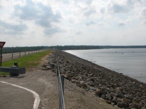
Excavation work and construction of the first section of the earth embankment for the west part of the dam began in July 1965, with the last section of the earth embankment completed in October 1975. Des Moines River flows were diverted through the outlet channel in July 1975, and the final section of the dam was built across the old channel of the Des Moines River between July and October 1975. The lake reached a conservation pool of 833 ft. mean sea level (msl) and became fully operational in September of 1977. The permanent conservation pool was raised to 836 ft. msl in 1985 and forms a lake of about 5,950 acres that extends some 17 miles upstream from the dam.
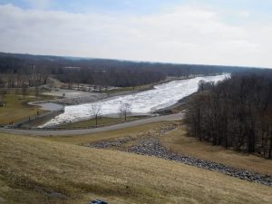
Saylorville dam is an earth dam with over 7 1/2 million cubic yards of compacted material. It is 6,750 ft. long, 105 ft. high, and 44 ft. wide at the top. The outlet channel is a single circular concrete conduit, 22 ft. in diameter, located at the bottom of the west bluff. The control structure is located at the upstream end of the conduit and houses three gates, which have the capability of releasing a maximum outflow of 21,000 cubic feet of water per second (cfs). A stilling basin is provided to dissipate the energy of the discharge from the outlet conduit.
 The full flood control pool at 890 msl is 54 miles long and covers 16,700 acres. This maximum flood elevation is 54 ft. above the normal lake level of 836 ft. msl. The spillway, located on the west side of the Administration Complex, sits at an elevation of 884 msl and acts as a backup system to the main outlet conduit. It is a passive system utilized only when lake levels exceed 884 msl. When lake levels reach the maximum 890 msl, it is estimated that 21,000 cfs of water will flow over the spillway.
The structure and planning of the Saylorville project was first fully tested as a flood control project in the spring of 1984. Lake levels reached a maximum height of 889.29 ft. msl, with water flowing over the spillway for 16 days. The resulting erosion below the spillway uncovered an extensive area, the Saylorville Gorge, which provides a unique look into Iowa ‘s geologic past. The flood control capabilities were again tested in 1991 and 1993. In all cases, the spillway provided the backup for which it was designed.
The dam, and resulting lake have several uses aside from the flood control aspect. Wildlife habitat is carefully monitored on the project and the quality of the habitat is improved through careful maintenance of the land. Water quality downstream from the dam is also improved by the siltation of soil into the lake before it is passed on downstream. In contrast to flood control, the lake is able to provide a steady water supply to the city of Des Moines in times of drought. You’ll also find a wealth of recreational opportunities in the lake area.
Saylorville Dam serves as the starting line for the Dam to Dam Half Marathon. On one side, runners get a beautiful view of Saylorville Lake, and to the other, they can see downtown in the distance.